Orgreave Lane and the junctions the Council tested
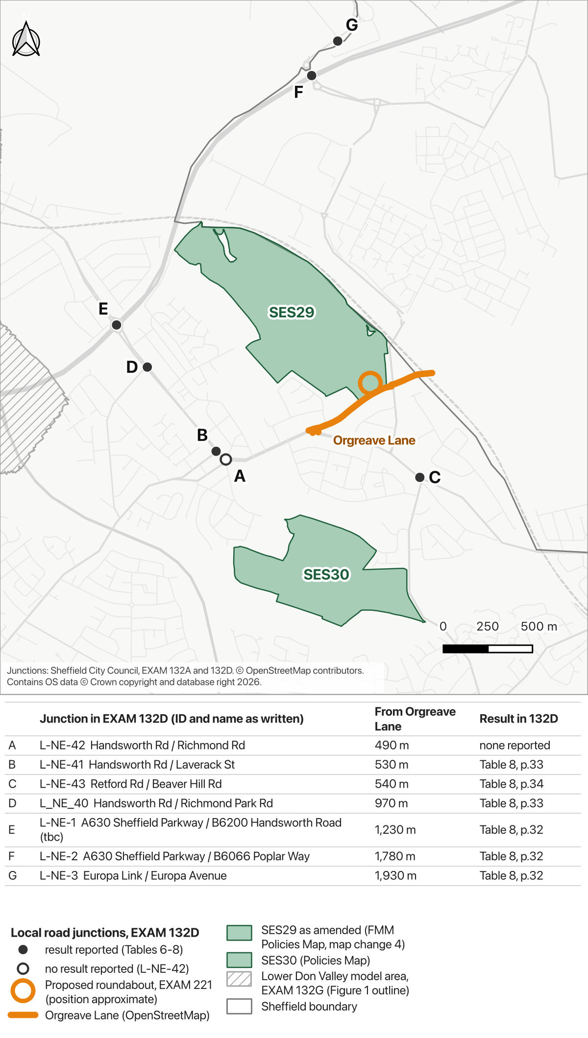
The latest plan for Handsworth Hall Farm (SES29) puts its access on Orgreave Lane, through a new roundabout. The Council's report on how the Plan affects local roads does not test a single junction on Orgreave Lane.
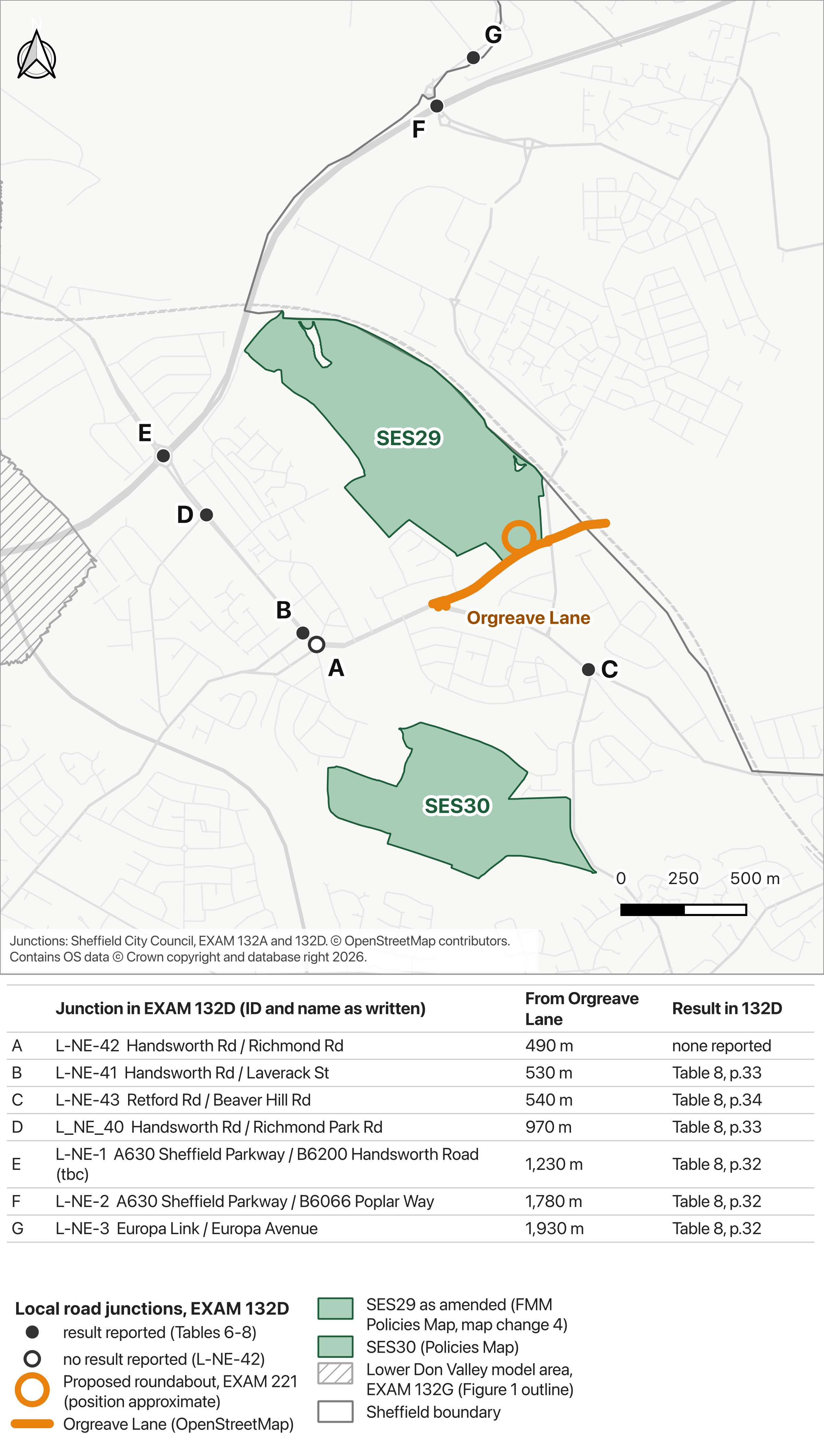
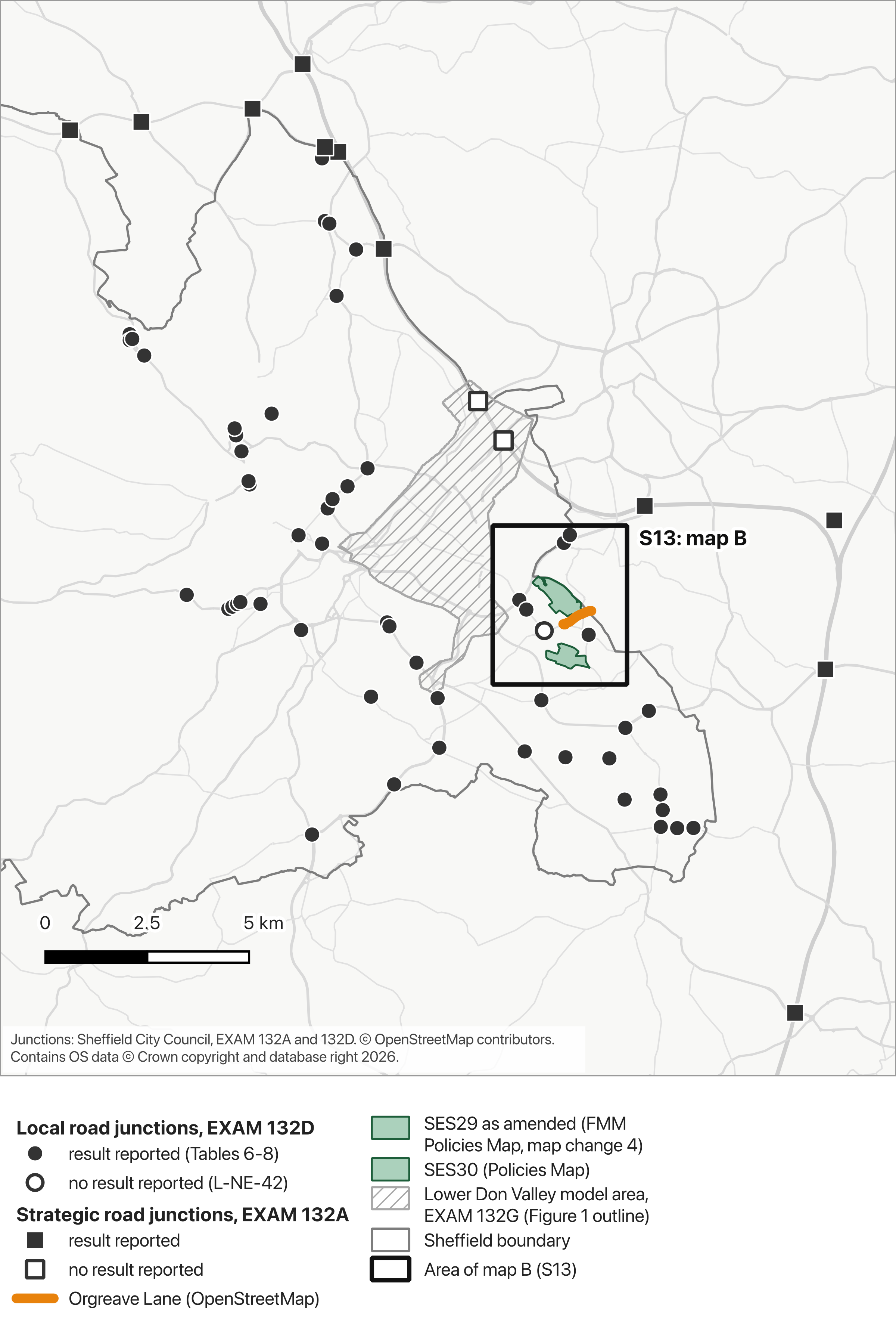
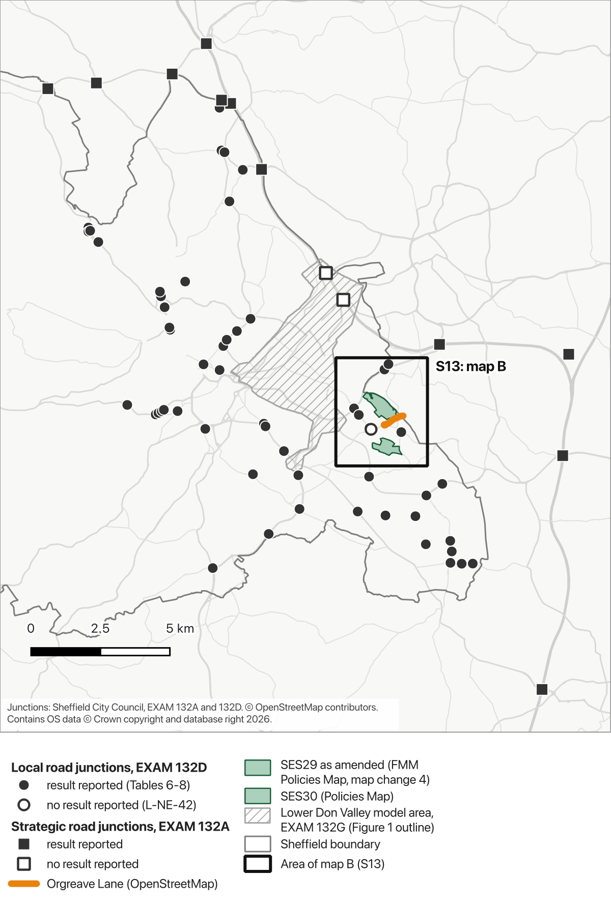
These maps show where separate junction results are reported. They do not show every road represented in the wider traffic model. Page references below are PDF page numbers.
Map B: S13. Filled circles mark local junctions with reported results. The hollow circle marks Handsworth Road / Richmond Road, listed without a result. Select the map to open the 2,400-pixel version.
“L_NE_40”, “(tbc)” and “B6066” are the report's wording/mistakes. A missing result means none is reported in the results tables.
What the local roads report covers
The Council's local roads report lists 56 junctions for detailed testing. None is on Orgreave Lane, including the junctions at either end.
Handsworth Road / Richmond Road is listed, but the report gives no result for it.
The city centre, Lower Don Valley and motorway junctions are assessed separately.
Sources and page references
EXAM 132D: junction list, Table 5, pages 20 to 23; results, Tables 6 to 8, pages 26 to 34; areas covered, pages 8 and 12. Motorway junctions are covered in EXAM 132A, page 29.
Map A: circles show local junctions in EXAM 132D; squares show strategic junctions in EXAM 132A. Filled symbols mean a result is reported; hollow symbols mean no result is reported. Green marks SES29 and SES30, orange marks Orgreave Lane, and hatching shows an approximate outline digitised from EXAM 132G, Figure 1 (PDF page 10).
M1 J34 North and South have no reported junction result. EXAM 132A says they are not included within this report because they form part of the Lower Don Valley modelling (paragraph 5.1.3, page 31). EXAM 132G includes J34 in its modelling but gives no junction results table for them. The hollow squares mean “no result reported”.
The Lower Don Valley outline is approximate and is not the full extent of the modelled roads. The nearest strategic junction to Orgreave Lane is M1 J33, 2.9 km away, measured in a straight line from the mapped lane. The method notes explain these measurements.
The access now proposed
The new roundabout appears in EXAM 221, page 3, dated 11 August 2026.
The letter says the design was informed by detailed analysis including traffic surveys (EXAM 221, page 1). We have not found those surveys published in the examination evidence checked for these maps.
The earlier modelling report says that, where Council plans were unavailable, SYSTRA made credible assumptions about which junction the development would use to access the road network (EXAM 132B, paragraph 5.2.4, page 34). It does not identify the junction assumed for Handsworth Hall Farm.
How SES29 and SES30 appear in the model
The transport documents checked for the maps do not use the references SES29 or SES30. They do include the land under earlier references. EXAM 132A, Table 11, page 38 lists Handsworth Hall Farm (S03061) at 983 dwellings and 80,000 square metres of employment. The same table lists Bramley Lane / Beaver Hill Road (S03020) at 878 dwellings (page 37).
EXAM 132G, PDF page 12 (printed page 10) reports morning-peak queues on the A57 Mosborough Parkway back from the Sheffield Parkway roundabout. It says these are further exacerbated by the additional allocations and that no mitigation has been identified for this location.
The report explains that the current arrangement meters traffic entering the wider network and deters further trips by private car. Its conclusions repeat that some impacts remain there and that highway mitigation is not considered desirable (PDF page 13, printed page 11).
Our questions for the Council
What evidence shows that Orgreave Lane and the junctions around it can take the traffic from the 870 homes and 20 hectares of employment land in MM410?
Why does EXAM 132D give no result for Handsworth Road / Richmond Road?
Will the traffic surveys behind EXAM 221 be published?
We placed junctions by their road names using OpenStreetMap, queried on 17 October 2026, then checked them against EXAM 132D, Figure 2 (page 24). Aligning that figure to mapped roads gave a root mean square error of 11.1 m. This measures the alignment of the source figure, rather than the accuracy of every junction.
Our confidence check records 41 high, four medium, eight low and three checked by hand among the local junctions. Every junction within three kilometres of SES29, in either junction layer, is high confidence or checked by hand. These are our assessments; the Council does not publish coordinates for these points.
You are welcome to reuse these maps: in your consultation comment, on social media, in a letter to your councillor or MP, or in a newsletter. If you spot an error, email info@saves13greenbelt.org.uk and we will correct it.
The allocation boundaries come from Council mapping that contains Ordnance Survey data. The Council's published Policies Map terms restrict redistribution of the data. We have not confirmed a separate open licence for the Council layers used here. Our permission concerns the campaign's work in the map images; it does not grant a licence to extract or redistribute third-party boundary data.