Historic parks and gardens map

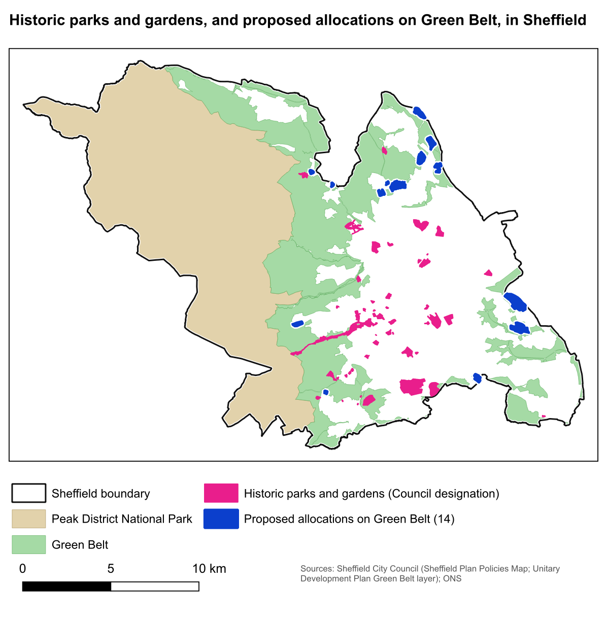
This map shows the Council's historic parks and gardens alongside the 14 areas proposed for development on Sheffield's Green Belt.
Download the map to use or share, or read the Further Main Modifications guide.
What the colours show
Pink shows the places the Council marks as historic parks and gardens. These include some historic cemeteries and similar grounds. The map does not show every park, woodland, playing field or other green space.
Blue shows the proposed development areas. Green is the existing Green Belt, and beige is the part of the Peak District National Park inside Sheffield.
South East Sheffield: what the Council's study found
South East Sheffield was 34.55 hectares short of allotments, parks and recreation grounds, and play space for children and young people, according to the Council's 2022 Open Space Study, South East Area Profile (Table 1, page 6).
It also found more than the Council's standards require in two other categories: 63.74 hectares more amenity green space and 407.22 hectares more accessible natural greenspace (the same table). These are the study's terms. Its findings cover more kinds of green space than this map shows.
For an idea of the size, Bramley Common (SES30) is 35.28 hectares (MM411, Schedule of Proposed Main Modifications, page 232). The study counts the different kinds of space separately, so this is only a comparison of size.
If you want to comment on the Plan
This map is background information. Historic parks are not a topic in the current Further Main Modifications consultation.
Our guide explains the four topics you can comment on: wildlife, local traffic, farmland and the Quaker burial ground.
Where the information comes from
The map brings together information from the Council's maps and the Office for National Statistics (ONS).
See the sources
- Historic parks and gardens: the Council's historic parks, gardens and cemeteries map information.
- Proposed development areas: the Council's Sheffield Plan Policies Map, Main Modifications.
- Existing Green Belt: the Council's Unitary Development Plan map.
- Peak District National Park: the boundary on the Council's Policies Map.
- Sheffield's boundary: ONS local authority boundaries.
- The study: South East Area Profile, Table 1, page 6. It is listed as OS13 in the examination document library, page 32.
Download and share the map
You are welcome to use this map on social media, in a letter to your councillor or MP, or in a newsletter. If you spot an error, email info@saves13greenbelt.org.uk and we will correct it.
For a comment on traffic in the current consultation, see the Orgreave Lane junction maps.
These downloads are copies of the finished map. We have not confirmed an open licence for the Council's mapping data used to make it. The Council's published map terms still apply to that data.