
Handsworth Hall Farm: the Wildlife Trust’s response
Shared with the campaign on
Removal of hedgerow at SES29, Orgreave Park/Handsworth Hall Farm
Dear Alyson
It has been brought to our attention that considerable hedgerow removal has taken place on the proposed Green Belt release site SES29, Orgreave Park/Handsworth Hall Farm. We are aware that Councillor Menday has made a formal complaint and requested that the Enforcement Team investigate further.
Although we have not visited the site, from the images and the information we have received we also have concerns regarding the legal basis for these works. We understand that, when approached by local residents, those undertaking the works described their purpose as being “to widen the stream”.
We recognise that the land remains agricultural land within the Green Belt. However, the site is also proposed for release through the emerging Sheffield Plan and is actively progressing through EIA Scoping for a major development. We therefore believe it is important that the purpose and legal basis for the works are established and evidenced.
The Town and Country Planning (General Permitted Development) (England) Order 2015 (GPDO), Schedule 2 Part 6 Class A, includes “any excavation or engineering operations” but only where these are “reasonably necessary for the purposes of agriculture within that unit”.
If it is suggested that the recent stream/watercourse works constitute agricultural permitted development, we would therefore ask what evidence has been provided to demonstrate that these particular works were reasonably necessary for agricultural purposes.
We would also question whether permitted development rights are available in these circumstances. The developer has already stated at section 5.1.2 of the EIA Scoping Report submitted under 26/02374/EIA that “the Proposed Development is EIA development requiring EIA to be undertaken.”
Article 3(10) of the GPDO provides that Schedule 1 or Schedule 2 development within the the EIA Regulations “is not permitted by this Order unless”, amongst the specified exceptions, the Local Planning Authority has adopted a screening opinion that the development is not EIA development, or the Secretary of State has made an equivalent screening direction. Therefore the relevant permitted development rights should be suspended.
If the Council is nevertheless minded to consider that permitted development rights apply, we would ask it to confirm whether the prior approval requirements under paragraph A.2 of Part 6 were engaged and, if so, whether the required prior notification and application for prior approval were submitted before the works commenced.
Irrespective of the purpose of the works, there is a separate issue concerning the removal of the hedgerow itself.
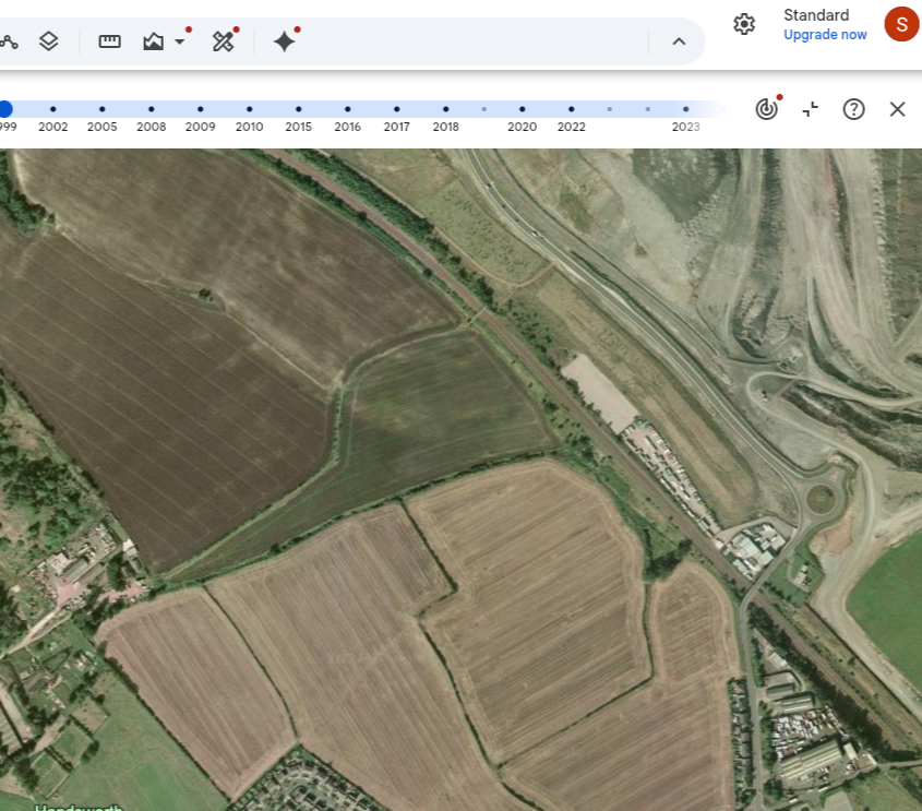
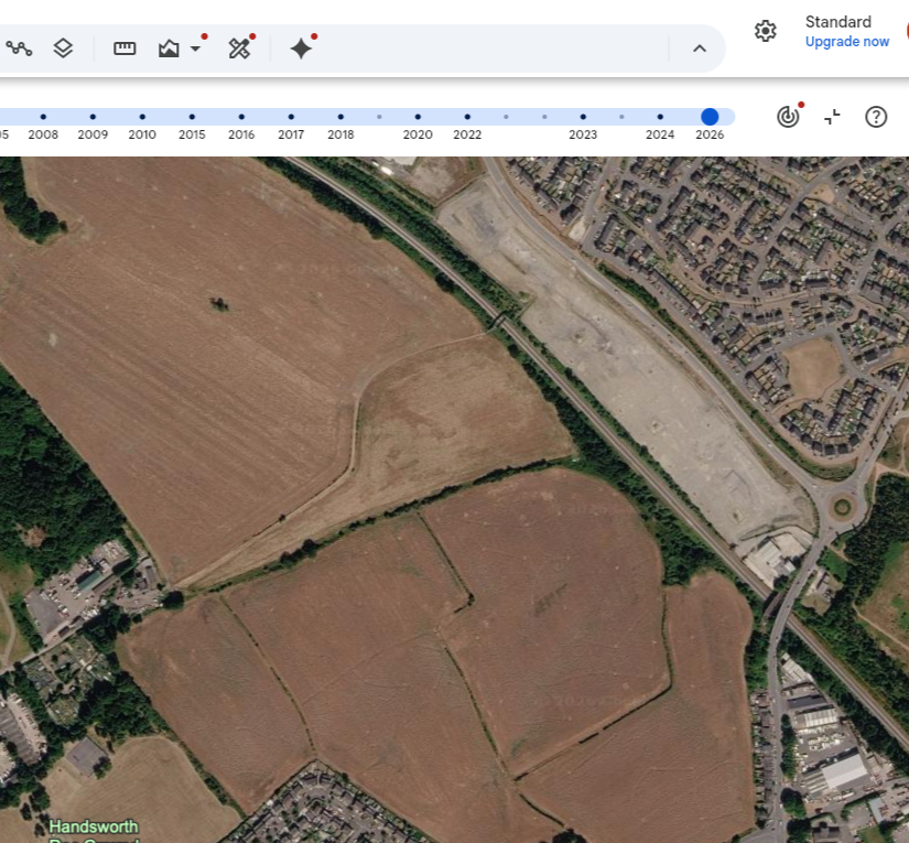
Using Google aerial imagery, the affected hedgerow appears to have extended for approximately 380 m (taking into consideration gaps of less than 20m). The affected hedgerow was also identified in the landowner's December 2023 Biodiversity Net Gain Assessment (published as part of the Sheffield Plan Examination) as H1, running alongside the watercourse identified as WC1.
The BNG assessment identifies H1 as part of the H1-H10 hedgerow resource across the site. It identifies WC1 as “Other Rivers and Streams” of High distinctiveness and Moderate condition. The report therefore provides important pre-clearance ecological evidence that H1 was recognised as hedgerow habitat and that the adjoining WC1 was itself regarded as a high-distinctiveness watercourse.
However, the December 2023 assessment is now out of date and, as we have raised previously, we have concerns that it may itself have underestimated the ecological value of the site's hedgerows, particularly given the association with a bank or ditch and the recorded species within the hedge. More recent ecological survey work has subsequently been undertaken in connection with the site and we would ask that this evidence is obtained and considered as part of the investigation.
Nevertheless, the 2023 BNG assessment remains important contemporaneous evidence of what was present before the recent works. It specifically records this hedgerow, the ditch and the trees along the ditch.
Pre-clearance aerial imagery and photographs of H1 also clearly show established trees growing within the linear woody vegetation alongside WC1.
We have additionally been provided with pre-clearance images of H1, the below image appears to show considerable diversity within the woody vegetation. We recognise the limitations of identifying woody species from a photograph, but the vegetation visible is likely to include a number of different woody species, including hawthorn, blackthorn, birch, hazel, oak, dog rose and Guelder rose.
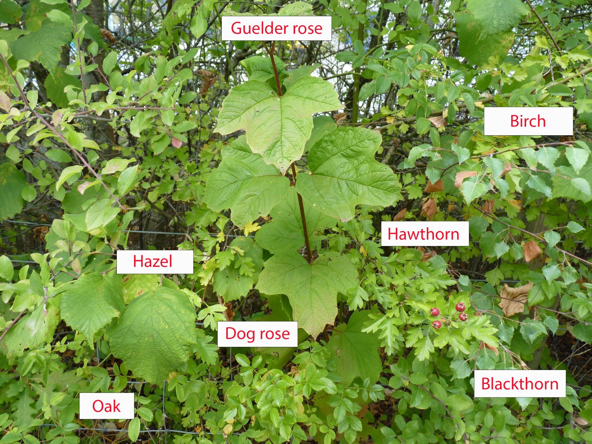
We do not suggest that photographic identification can substitute for the field survey methodology required to determine whether a hedgerow satisfies the Schedule 1 criteria for an “important hedgerow”. However, it provides evidence of sufficient apparent woody-species diversity to raise the question of whether H1 was properly assessed against those criteria before its removal.
The field boundary itself can be demonstrated on historic mapping dating from at least the 1850s. We would therefore ask whether H1 was assessed against the Schedule 1 criteria for an “important hedgerow” before the works took place, including its age and historic significance, woody-species composition, ancient indicator species, associated features and relevant ecological records.
Google Earth Dec 1999-July 2026
OS maps from surveyed 1850-1851
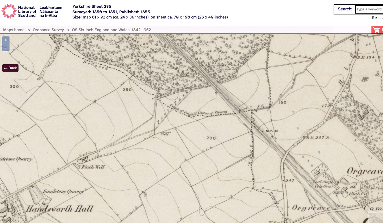
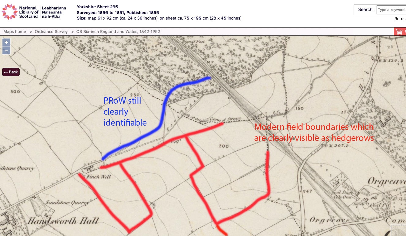
Throughout the Sheffield Plan consultation and Examination process, we have repeatedly raised the need for hedgerows within proposed Green Belt release sites to be subject to an integrated landscape, heritage and ecological assessment. This is necessary to establish not simply their current habitat classification, but their historic origins, continuity and whether they may qualify as ancient or irreplaceable habitat. The apparent presence of this boundary on mapping dating from at least the 1850s reinforces the importance of such an assessment in this case.
The presence of the adjoining watercourse/ditch and established trees is particularly relevant to that assessment.
The Hedgerows Regulations 1997 establish a separate statutory regime controlling the removal of qualifying countryside hedgerows. Subject to the specific exceptions within Regulation 6, a hedgerow to which the Regulations apply cannot simply be removed without the required notification procedure.
We therefore ask the Council to confirm:
- whether a Hedgerow Removal Notice was submitted in respect of H1;
- if not, whether the Council considers that any of the Regulation 6 exceptions applied and, if so, which exception and on what evidence;
- whether H1 was assessed against the Schedule 1 “important hedgerow” criteria before its removal; and
- if the removal was undertaken in contravention of the Regulations, whether the Council will exercise its powers to require an appropriate replacement hedgerow.
There is also a separate potential issue under the Forestry Act 1967.
The Forestry Commission's current guidance expressly confirms that trees standing within hedgerows may require a felling licence and that hedgerow trees are treated as part of the hedgerow for the purposes of the relevant hedgerow controls.
Pre-clearance aerial and photographic evidence shows a number of established trees within H1. Because those trees have now been removed, it is difficult for us to establish their individual stem diameters or the volume of timber felled retrospectively.
We have therefore referred the matter to the Forestry Commission.
Given that the removal of H1 has now altered or destroyed some of the physical evidence which would otherwise have been available for assessment, we would also ask the Council to identify and provide any ecological surveys, assessments or other ecological evidence upon which it relies in reaching its conclusions in relation to this case. This should include any more recent PEA, hedgerow survey, habitat condition assessment, species survey or other ecological information relating to H1, WC1 and the trees which have now been removed. Given the scale and nature of the clearance, and the ecological and historic evidence relating to H1, we would urge the Council to use the powers available to it to secure the restoration of this hedgerow along its former alignment.
We would be grateful if you could keep us informed as to the progress of your investigation.
Thanking you in anticipation.
Susan and Scarlett
Advocacy Team
Sheffield & Rotherham Wildlife Trust